

Pebbles containing hidden sensors are helping coastal scientists and engineers to manage erosion and flood risk at locations along England’s south coast.
The ‘tracer pebbles’ – which contain RFID tags supplied by Lancashire firm CoreRFID – are being used to track sediment as it moves along the shoreline under wave action. The results provide a powerful tool to aid beach management decisions and the design of coastal defence schemes.
The system was developed over 10 years ago by Coastal Partners, which manages flood and erosion risk on behalf of five local authorities on the south coast. The organisation has carried out over ten studies to date and now has over 9,500 pebbles deployed at a range of different sites.
A year-long study at West Bay in Dorset has recently been completed, with the results now being analysed, while a new study has begun at Selsey, near Chichester where 400 tracer pebbles have been deployed.
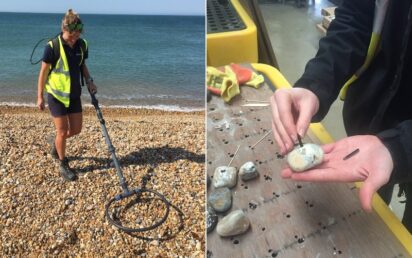
Tracers consist of pebbles taken from the beach, drilled by a water jet and fitted with an RFID tag. They are then positioned along a stretch of coastline, and their location logged using GPS. Team members carry out regular surveys by walking the beach with a specialist RFID scanner which bleeps each time a tag is detected and automatically logs its ID number and GPS position. The data can then be uploaded, analysed and displayed in various different formats.
The pebbles contain passive RFID tags without a battery so they can be left in the field for long periods, and with a detection range of up to 1m. On average 72% of tags are detected over a two-week period, with more than 95% of all tags detected more than once.
Beach management is vital wherever erosion poses a risk to lives or property. Traditionally aerial photography and topographic data have been used to identify movement but the data can be limited.
Emma Harris, a scientist with Coastal Partners, said: “By measuring the profile of a beach, we can see that material is being lost, and where it needs to be replaced, but we can’t see where it is going to. The beauty of using tracer pebbles is that we see the direction in which material is being transported and how fast. It’s another piece of the jigsaw and gives us a better understanding of what’s going on.”
Coastal Partners had originally sourced tags from overseas but following Brexit, decided to look for a UK supplier. CoreRFID recommended encapsulated, low frequency glass tags that were compatible with their existing readers, able to survive harsh environmental conditions and whose size and shape made it easy to insert them into pebbles.
Richard Harrison of CoreRFID, an RFD specialist which is based in Skelmersdale, said: “Coastal Partners have developed a novel and cost-effective system that has been extremely effective in providing the data they need to help prevent coastal erosion and safeguard lives and property.
“RFID’s ability to identify and track individual items offers huge scope for creative applications, whether it is pebbles on a beach or items on a production line. By incorporating RFID into existing systems, it can help businesses to fill in some of the gaps in the data and build a more detailed picture.”