
Every year, vast swathes of the world’s forests vanish, leaving behind barren landscapes and broken ecosystems. This relentless deforestation not only threatens countless species but also accelerates climate change, impacting the entire planet. Yet, as the chainsaws roar and fires consume green canopies, there is hope — from above.
Satellites, orbiting high above Earth, have become our eyes in the sky, offering a unique view of forest loss and the ability to monitor this global crisis in near real-time. By harnessing historical and current satellite imagery, we can now understand the scale of deforestation better, identify hotspots of illegal activity, and develop strategies to protect these vital resources.
This piece will cover two stories of deforestation of different nature to showcase how EOS Data Analytics, a global provider of advanced satellite data analysis, helped solve this issue.
Deforestation For Oil Palm Cultivation
With the global demand for palm oil showing no signs of slowing down, vast areas of tropical rainforests are being systematically cleared to make way for new plantations. This relentless expansion not only wipes out rich biodiversity and destroys critical habitats but also results in the fragmentation of entire ecosystems, making it harder for species to survive. Moreover, these deforestation practices contribute significantly to greenhouse gas emissions, accelerate soil degradation, and alter water cycles, leading to long-lasting environmental repercussions.
In early 2024, Malaysian journalist Choon Chyuan Low decided to tackle this issue head-on by publishing an investigative report titled “Timber Grab: The Truth Behind Pahang Oil Palm.” Supported by the Pulitzer Center and featuring research from EOS Data Analytics, the report uncovered a troubling case in the Pahang region, where the supposed development of oil palm plantations was, in reality, a façade for rampant illegal timber extraction. Low’s investigation exposed how the local government, through its development corporation, had authorized deforestation in the name of agricultural expansion while reaping the profits from timber sales, leaving the land scarred and unsuitable for sustainable plantation management.
The collaboration with EOSDA proved instrumental in revealing the scale of the damage. Using satellite imagery of the Earth and historical data analysis, EOSDA was able to track deforestation patterns over time, visualize forest loss, and even estimate the potential carbon emissions resulting from these activities. Low’s findings, backed by these advanced analytics, showcased not only how much forest had been lost but also its direct impact on local communities and wildlife. The evidence provided by EOSDA allowed Low to illustrate the broader implications of the issue — the story was no longer just about one plantation but a wider, systemic problem of corruption, mismanagement, and environmental harm.
EOSDA’s involvement went beyond merely providing archive and recent satellite images. The team conducted detailed research to calculate the carbon sequestration potential of the deforested areas, highlighting the broader consequences of land-use change. This data gave Low the necessary scientific grounding to quantify the true environmental cost of the illegal activities and draw attention to the urgent need for better land management practices and policy reforms.
By empowering journalists like Choon Chyuan Low with robust insights, EOSDA is helping to bridge the gap between environmental science and public awareness. Their partnership in this investigation exemplifies how technology and journalism can collaborate to hold powerful entities accountable and foster meaningful conversations around conservation and sustainable development.
Baobab Forests Loss
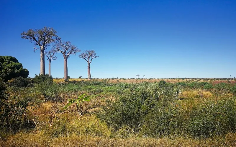
Deforestation driven by human activities and climate change is pushing Madagascar’s iconic baobab trees to the brink. These ancient giants, central to the island’s ecosystem and the livelihood of local communities, are facing a myriad of threats, including illegal logging, agricultural expansion, and habitat loss. As the baobab population dwindles, the urgency to protect them has become paramount.
In response, EOSDA joined forces with local conservationists like Dr. Seheno Andriantsaralaza, president of the Group of Specialists Passionate about Baobabs of Madagascar (GSPBM). Using their technology to analyze satellite view of the Earth, EOSDA helped assess the impact of deforestation in regions like the Ankarana Special Reserve. Their analysis revealed that extensive habitat loss has released an estimated 85,000 tons of carbon dioxide over the past five years — emphasizing the broader environmental consequences.
Together with EOSDA’s support, Dr. Andriantsaralaza’s team launched a reforestation initiative in 2021, establishing nurseries to cultivate over 50,000 native trees, including baobabs. By involving 300 local community members, they successfully transplanted thousands of seedlings in early 2023. EOSDA’s most recent satellite images have already shown promising vegetation growth in these areas, suggesting that the initiative is helping restore the fragile ecosystem.
Both the Malaysian timber grab case and Madagascar’s baobab conservation efforts illustrate the power of satellite technology in tackling deforestation. With tools like those offered by EOSDA, conservationists and journalists can expose illegal activities, support reforestation, and drive sustainable land-use practices. These stories demonstrate that when technology and human passion unite, they become a formidable force in protecting our planet’s precious forests for future generations.